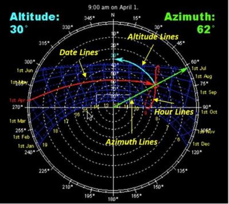
Reading Sun Path Diagrams
Sun path diagrams can tell you a lot about how the sun will impact your site and building throughout the year. Stereographic sun path diagrams can be used to read the solar azimuth and altitude for a given location.


Stereographic Sun Path Diagrams
Note that these stereographic diagrams are not exactly like a fish-eye photo: such an image would be flipped left-to-right. These diagrams are from the point of view of the sky looking down at the ground, you can superimpose it on a map or a plan of the building without being confused. (You can see this by following the hour lines from east to west on the diagram.)
Azimuth Lines - Azimuth angles run around the edge of the diagram.
Altitude Lines - Altitude angles are represented as concentric circular dotted lines that run from the center of the diagram out.
Date Lines - Date lines start on the eastern side of the graph and run to the western side and represent the path of the sun on one particular day of the year.
Hour Lines/ Analemma - Hour lines are shown as figure-eight-type lines that intersect the date lines and represent the position of the sun at a specific hour of the day. The intersection points between date and hour lines give the position of the sun.